Drone Construction Progress Tracking Package
Drone Progress Tracking for Construction and More
Stay ahead of your construction schedule with our professional drone progress tracking services. Designed for construction clients who demand accuracy, efficiency, and speed, our service provides detailed aerial documentation to keep your project moving smoothly.
Our state-of-the-art drones capture high-resolution imagery and data, delivering a clear, comprehensive view of your site's progress. From large-scale developments to intricate builds, we ensure your team has the insights needed for better decision-making.
Need results fast? We offer expedited service with rapid data processing and expedited turnaround for an additional fee. Whether you're addressing tight deadlines or tackling unexpected changes, we’re here to help you stay on track without compromising quality.
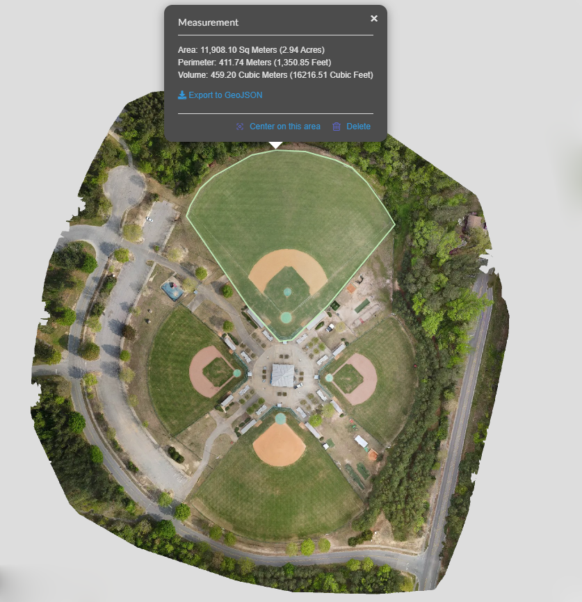
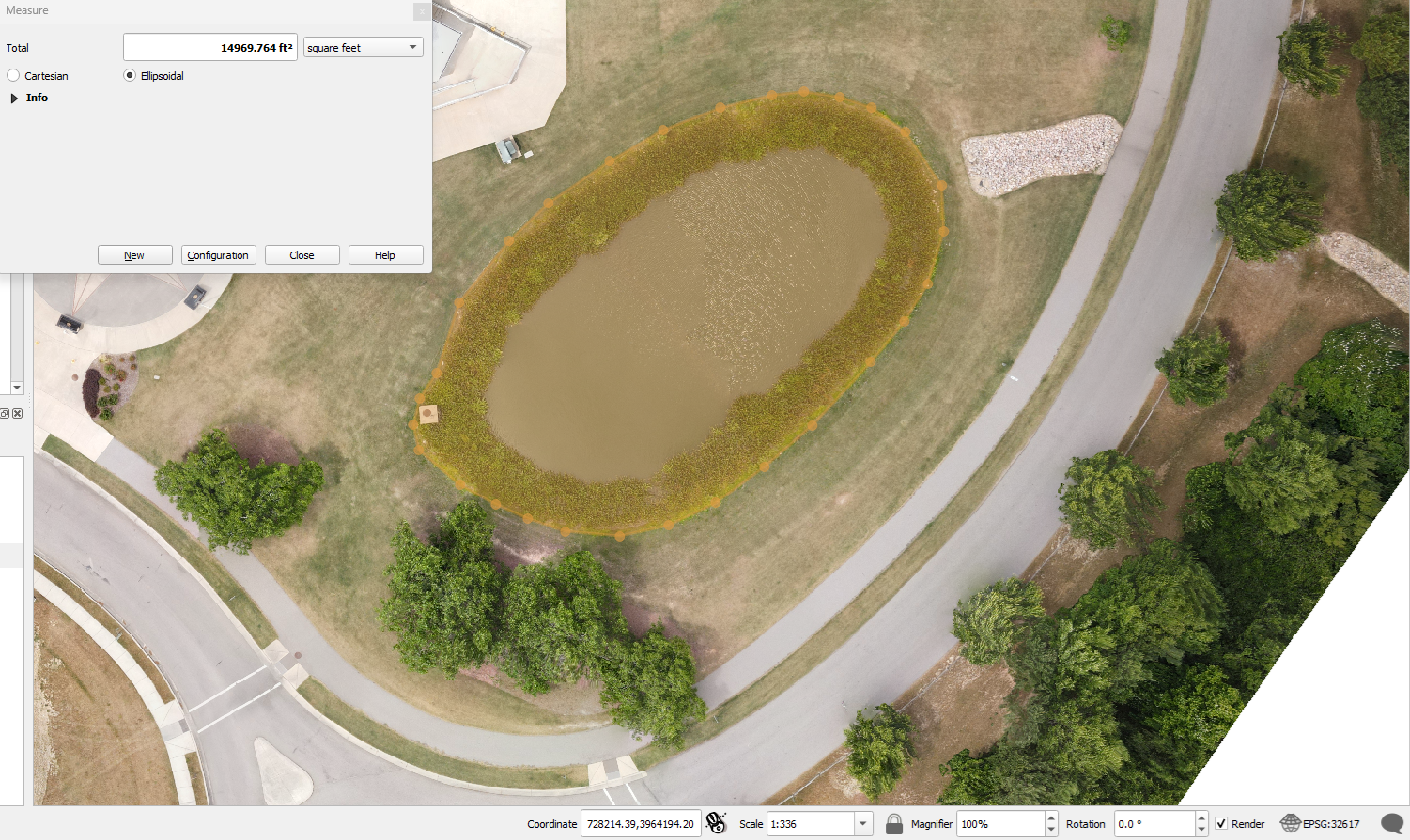
We also provide several extra bits of data completely for free. All scans include tiff files which can be opened inside of any GIS software. This allows our customers to view geo locations, calculate distances, measure areas, and much more. All scans will also include a detailed PDF report showing a summary of our work during each visit. We are always working to improve our data collection and provide even more accurate collection with our drones. Soon we will have centimeter precision on our mappings even up to hundreds of acres.
Simplify your construction tracking with our trusted drone services. Reliable data, faster decisions, and a clearer path to success—all from the sky.
Please not that the price given is just a quotation. All final prices may be subject to change based on the scope of the project or any additional requirements. This quote is just to start the reservation process for our flight time and to start out a contract for our services.Drone Progress Tracking for Construction and More
Stay ahead of your construction schedule with our professional drone progress tracking services. Designed for construction clients who demand accuracy, efficiency, and speed, our service provides detailed aerial documentation to keep your project moving smoothly.
Our state-of-the-art drones capture high-resolution imagery and data, delivering a clear, comprehensive view of your site's progress. From large-scale developments to intricate builds, we ensure your team has the insights needed for better decision-making.
Need results fast? We offer expedited service with rapid data processing and expedited turnaround for an additional fee. Whether you're addressing tight deadlines or tackling unexpected changes, we’re here to help you stay on track without compromising quality.
We also provide several extra bits of data completely for free. All scans include tiff files which can be opened inside of any GIS software. This allows our customers to view geo locations, calculate distances, measure areas, and much more. All scans will also include a detailed PDF report showing a summary of our work during each visit. We are always working to improve our data collection and provide even more accurate collection with our drones. Soon we will have centimeter precision on our mappings even up to hundreds of acres.
Simplify your construction tracking with our trusted drone services. Reliable data, faster decisions, and a clearer path to success—all from the sky.
Please not that the price given is just a quotation. All final prices may be subject to change based on the scope of the project or any additional requirements. This quote is just to start the reservation process for our flight time and to start out a contract for our services.What Comes with This Service?
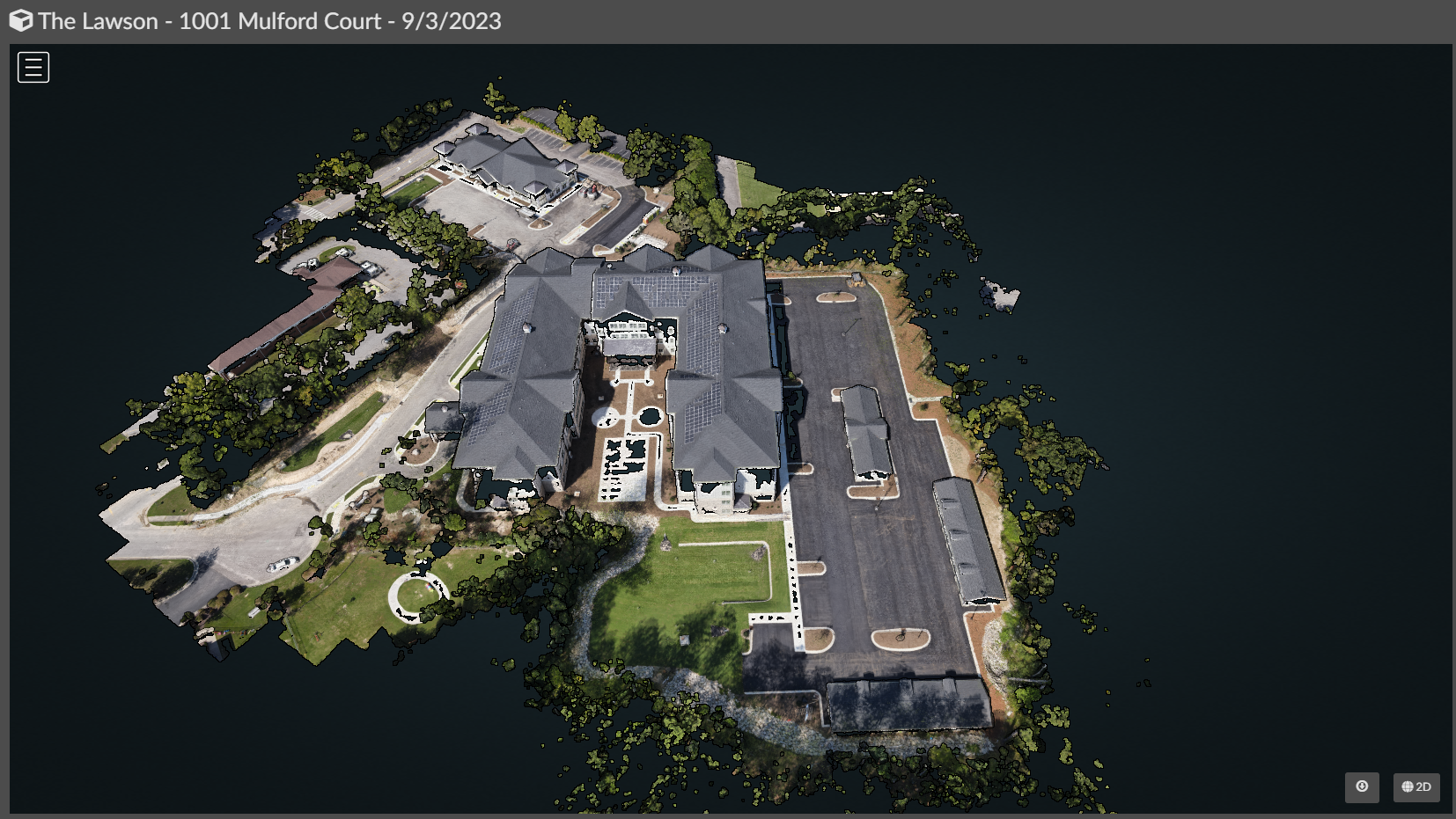
One Large Scale Drone Mapping: We get one high resolution image of your entire property up to 100+ acres. These help to get the best snapshot of progress.
Seven to Ten Aerial Photos of the Property: Receive a few extra shots of the property for social media and advertising as well as further progress tracking.
GIS Data: We can export our mappings into any GIS software to help with planning, take measurements, and more! We use TIFF files or LAZ files.
FREE Hosting: All hosting and cloud storage is included with each package and your data is kept for one year after the conclusion of our contract. For further hosting or special data needs just ask.
Results PDF: Get a PDF report showing our GPS accuracy and other key notes about our drone operations for each mission.
Video Services Available at Request: Normally most video requests are for short One and a half or two minute edited clips of the location. Some clients just want the raw files. We are open for discussion.
Why Choose Us?
Accurate Progress Monitoring: Get precise, up-to-date visuals and metrics tailored to your project.
Quick Turnaround: Receive professional results quickly when time is of the essence.
Enhanced Communication: Share progress updates seamlessly with stakeholders through detailed reports and visuals.
Customizable Solutions: Services are tailored to your unique project needs and deadlines.